| home | pg. 1 | pg. 2 | pg. 3 | pg. 4 | pg. 5 | pg. 6 | pg. 7 | pg. 8 | pg. 9 | pg. 10 | pg. 11 | pg. 12 | pg. 13 | pg. 14 | pg. 15 | pg. 16 | pg. 17 | notes | Transylvania detail 1 | Transylvania detail 2 | Wolcott detail | Bibliography | D. Gorton Homepage | Jane Adams Homepage
|
|
Reading the Photographic Record
by
Jane Adams
D. Gorton
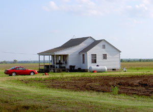
Empirical data about material culture1. The photos have a wealth of raw empirical evidence of life at the time. They provide data about the processes through which projects formed, their composition, and their organization. Though our interest focuses on understanding social relations in the Delta and we are not historians of technology or architecture, we must have some grasp of these phenomena, because they create foundations on which people build their lives.People we interviewed who grew up on FSA projects in the Delta told us repeatedly of the marvels of moving from their sharecropper shacks to the new FSA homes. Some took us through their homes, remodeled by successive generations. And aerial photos sometimes revealed the still-extant property lines and siting of homes. However, some 65 years or more have passed since these projects were created, and much has changed. The cooperative farm at Lake Dick, for example, has reverted to one vast private plantation, with very little left except the village center. |
 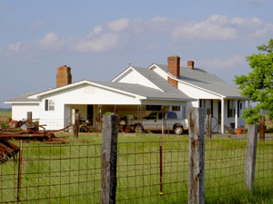 Houses at Plum Bayou, Arkansas, summer 2006. Photo by D. Gorton. |
| We wanted to see these projects as their planners had conceived them. We could partially reconstruct these through plat maps on file in the county courthouse that revealed the 40-60 acre plots the FSA recipients had been given. | 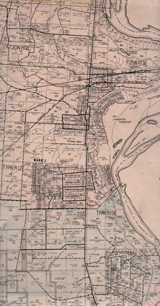 Transylvania, Louisiana, plat. East Carroll Parish Court House |
|
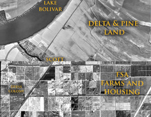
And aerial photos sometimes revealed the still-extant property lines and siting of homes. Aerial photos like the images here of Dyess, Arkansas, which was one of the first Resettlement Administration Project, and Delta & Pine land, which has been operated only as a plantation, show the traces the New Land reform have left on the landscape. |
 |
| However, some 65 years or more have passed since these projects were created, and much has changed. The cooperative farm at Lake Dick, for example, has reverted to one vast private plantation, with very little left except the village center. | 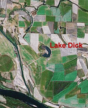 Lake Dick is the oxbow lake in the cneter of this image, copied from GoogleEarth. (Screenshot, insert in Photoshop and saved for web). It's land pattern is indistinguishible from the plantations surrounding it. |
| home | pg. 1 | pg. 2 | pg. 3 | pg. 4 | pg. 5 | pg. 6 | pg. 7 | pg. 8 | pg. 9 | pg. 10 | pg. 11 | pg. 12 | pg. 13 | pg. 14 | pg. 15 | pg. 16 | pg. 17 | notes | Bibliography | Transylvania detail 1 | Transylvania detail 2 | Wolcott detail |
|
|